
Using Watershed Data to Determine Cost-Effective BMPs
A study from researchers at Penn State and U.S. Department of Agriculture (USDA) provides a case study that using site-specific watershed data to determine the most cost-effective agricultural best management practices (BMPs) is not only less expensive, but equally effective.
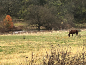
Researchers used the Spring Creek watershed — which drains an area of about 150 square miles into Bald Eagle Creek, a tributary of the Susquehanna River — for the project because it is one of the best-studied watersheds in the Chesapeake drainage. (Credit: Sue Morgan)
Researchers used the Spring Creek watershed, an area of about 150 sq. miles that drains into Bald Eagle Creek, because it is one of the best studied watersheds in the Chesapeake drainage. Data about stream flows, nutrient and sediment loss, and the landscape in Spring Creek have been monitored for decades by Penn State, USDA scientists, and the U.S. Geological Survey. The study was funded by the EPA and USDA.
Customizing a BMP adoption plan
Researchers used a watershed model called the Topo Soil & Water Assessment Tool (SWAT) to simulate the hydrology, geology, and topology of the Spring Creek watershed. The model was calibrated and validated to incorporate local agronomic expertise as well as 12 years of previous water monitoring data and site knowledge. Mostofa Amin, a postdoc at Penn State when the study was conducted, and Tamie Veith, an agricultural engineer with the USDA, developed the Spring Creek model as part of the interdisciplinary Penn State Center for Nutrient Solutions team.
The Spring Creek watershed is a karst area, meaning the watershed has a lot of limestone and sinkholes. Veith explained that this is a major geophysical characteristic that has to be accounted for when creating a model. “A lot of the modeling simulates runoff over the land surface and doesn’t consider the geology below. If you do not properly capture the water movement below the land surface, your model won’t be accurate.”
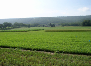
One of the best management practices used in the Spring Creek simulation was nitrogen management, which on cropland like this results in 15% less nitrogen input. (Credit: Heather Karsten)
This accuracy is a concern that a lot of people have raised about the utility of the Bay model, said Heather Karsten, an associate professor of crop production and ecology at Penn State. “The Bay model can’t capture all those details within that area of the watershed; instead it captures the watershed as one river segment.” Although the Spring Creek watershed is a smallest hydrologic unit, as considered by the Bay model, the modeling used by Veith and her colleagues zooms in to represent the Spring Creek watershed as the largest unit, allow much more detailed spatial analysis within the watershed.
Using the customized Spring Creek model, the team designed a cost-effective BMP adoption plan that achieved equal or greater load reduction as the federal requirements for 74% of the cost by applying only five of the eight BMPs — no-till, manure injection, cover cropping, riparian grass buffers and 15% reduction in nitrogen inputs — recommended in the Pennsylvania watershed implementation plan (WIP), informed by the Chesapeake Bay Model.
Expanding the model
If using site-specific watershed data to determine the most cost-effective BMPs saves both money and time, shouldn’t this practice be expanded to other watersheds?
Both Karsten and Veith emphasized that it not only takes time, but also open dialogue between the community and researchers. “It takes sitting down with the community to see what has already been put in place, what water quality data exists, and what farming practices look like in that area before creating a model like SWAT,” explained Veith. The process is resource intensive, with a lot of data collection, time, and collaboration, but Karsten shared that, “Communities want a voice and to be more engaged. They want to know what works and what is most cost-effective for their region.” In addition to the community stakeholders, Karsten highlighted the importance of having an interdisciplinary team that understood everything from field research to modeling the watershed hydrology.
Moving forward, Veith said that the goal is to see how to extend these results and generalize them as appropriate for other similar watersheds. “Our results indicate that there’s promise for regions and watersheds to achieve the goals in a more cost-effective way. It would require some fine-scale models and assessments to understand what would be more cost-effective, but it would work.”