
How do you protect a stream if you do not even know it is there? Matthew Baker of University of Maryland Baltimore County (UMBC) is creating more accurate maps of the Chesapeake Bay watershed with non-profit partner Chesapeake Conservancy. The team was recently awarded $1.2 million from the Chesapeake Bay Program (CBP) to implement new stream mapping techniques.
Baker is a watershed scientist whose research focuses on the effects of geomorphology and hydrology on stream ecosystems. He has spent time studying the effects of riparian buffers on pollutant discharges to the Bay and of land use change on stream integrity. “In many research endeavors, knowing the characteristics of a stream network is critical for understanding where interactions take place and how impacts are communicated across the landscape,” he explained.

Pictured are three different stream heads. On the left is a flow wash, where leaves have been removed by concentrated flow. The next two are heads with distinct topographic steps, one associated with a boulder and the other associated with tree roots. The first two are difficult to map accurately because they do not have well defined stream banks, whereas the third is relatively easy to map. Credit: Matthew Baker.
Tracking headwaters is particularly important for Bay restoration because they are often the location where excess agricultural pollutants enter streams. Baker explained that low order channels, or the headward fingertips of a drainage network and their confluences, often make up a large fraction of the total length of a channel, and take in a high proportion of the water that will enter the stream. Headwater streams are particularly vulnerable to dirty stormwater runoff and urbanization, and are often subsumed or rerouted by development. “While most streams are like veins or arteries, headwater streams are like capillaries. They are much more strongly impacted by human land use and they facilitate exchange between the surrounding landscape and downstream ecosystems,” said Baker.
Without mapping small streams, scientists and managers might infer that water or nutrients are moving over or through landscapes, when really they are being transported in channels. This could impact decisions on where to implement stream buffers and other best-management practices designed to reduce pollutant discharges. “If we want to understand what places and processes are important for transporting pollutants, we have to correctly attribute flow paths through land and water ,” Baker explained, adding that how far the nutrients travel and where they are coming from can have huge implications for conservation and management.
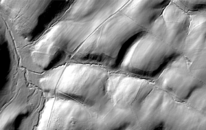
This image shows the shaded relief from a LiDAR digital elevation model of some headwater streams. In the image, you can see channels, but they appear to be discontinuous in many places and very similar to roadways. Credit: Matthew Baker.
In 2017, Baker and the Conservancy received a grant from the Chesapeake Bay Trust to develop an automated technology for extracting stream maps from detailed topography derived from Light Detection and Ranging (LiDAR) surveys. LiDAR maps are created by lasers shot down from aircraft to measure the relative height of Earth’s surface, showing in great detail small changes in terrain. ” We are training a computer to use a topographic map to find channels in much the same way your eye and your brain would detect them in shaded relief,” he explained. Now that the technique has been refined for this purpose, Baker and his team can apply their approach across the watershed.
In developing their technique, Baker and the team at Chesapeake Conservancy wanted a methodology that accurately detected headwater channels in all their different forms. This required them to conduct some fieldwork. They collected information from New York to Virginia and Appalachian Mountains to Coastal Plains about where streams began, then compared the strengths and weakness of different techniques for detecting such locations. “We wanted to develop an approach that found the many small channels that do not appear on current maps, without inadvertently delineating channels that are not actually there,” Baker added.
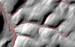
The red lines show where their algorithm thinks channels are, including a few roadside ditches. Credit: Matthew Baker.
Baker’s method looks for topographic features characteristic of channels, such as relatively long and narrow depressions that are higher on the sides than on their ends. In contrast, previously developed techniques simply looked for low areas and connected them following the steepest path down-slope. One challenge with using LiDAR is dealing with impasses on flowpaths, such as produced by thickets, trees, culverts, or bridges, that can appear to block water flow. If a person were to look at a topographical map, they would be able to infer that the water moved under or through the impasse. The team developed an algorithm that works in a similar way, so that the computer interprets blockages as traversable if there is evidence of a channel immediately downstream.
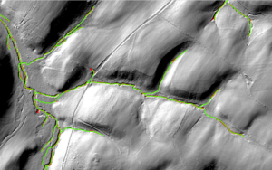
Baker’s team produces the lines shown in green. Credit: Matthew Baker.
The Chesapeake Conservancy was a fitting partner for the project because “the Conservancy has extensive experience developing high-resolution datasets in the Bay watershed and is invested in using such information to guide conservation efforts,” Baker said. Baker also hopes these maps will be able to show changes over time that have never been documented before. “We’ve been occupying and transforming the landscape for a long time. Because many headwater streams do not show up on maps, unless someone took a photograph for an archive, there has been very little record of the what we have lost or added to the landscape. A map can help document the cumulative effects of land transformation.”
With this robust technique, Baker and the Chesapeake Conservancy will be able to map the Bay watershed in a novel way. Then, their method could be used in other watersheds, supporting protection of waterways across the country and around the world.