
VIMS Helps State Prepare for Oil Spills on the Eastern Shore
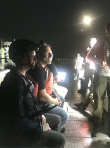
Verizon ran additional deployment operations at night, in part to test night vision capabilities. Emily Hein (VIMS) is wearing a helmet-mounted camera streaming live video and audio back to shore and an s-band radio, next to Brian Province (Maersk Line, Ltd). Credit: Aaron Allen, Maersk Line, Ltd
Off the coast of Virginia’s Eastern Shore, shipping vessels move continuously between the Chesapeake Bay, the Delaware Bay, and major ports farther north. But the coastline is lined with barrier islands and pristine salt marshes, home to many of the most sensitive organisms in the state.
That’s why federal, state, and local agencies come together regularly to prepare in the event of an oil spill. The National Preparedness for Response Exercise Program (PREP) was developed to establish and exercise program to meet the intent of the Oil Pollution Act of 1990. A variety of smaller exercises occur yearly, but every 4 years, all partners involved in a spill response participate in a full-scale drill with an incident command post and actual equipment deployments.
Understanding the logistics of a major drill spill
Animation of the NOAA oil trajectory model results. Note the wind speed and direction in the upper right corner and the time and date stamp in the very bottom left. Credit: NOAA
For this particular exercise, the scenario was that an imagined shipping container moving north 20 miles off the coast discharged 2,500 barrels of heavy fuel oil that the crew doesn’t notice due to faulty alarms and sensors until 2 hours later. The oil is headed towards the beaches and tidal marshes of Virginia’s barrier islands, centered on Parramore and Cedar islands.
While in reality, there are a lot of safety factors and redundancies on ships that would prevent this from happening, and it’s doubtful that it would take 2 hours for crew to notice a spill, the team wanted to prepare for a worst-case scenario. Agencies were tasked with conducting a response to this scenario, practicing the steps necessary to prevent the most harmful damage to the coastline.
Emily Hein serves as the Virginia Institute of Marine Science (VIMS) representative on the statewide group that planned the drill, the Virginia Area Committee of the U.S. National Response Team. The committee is led by the U.S. Coast Guard, co-chaired by Virginia Department of Environmental Quality, and involves state, federal, private industry, and non-government agencies. They meet quarterly to plan for spill responses and discuss recent incidents.
She noted that the most important aspect of the drill is opening the lines of communication between the dozens of agencies and organizations involved in spill response. “Furthering communication and relationships is part of why we have these big exercises,” she said. “The last thing we want during an actual spill response is meeting somebody for the first time.”
The drill is also an opportunity to practice using the Incident Command System (ICS), a common language and operational structure developed by FEMA so that every individual understands their tasks in the spill response. ICS controls the structure of the people in teams, the units within the response, and it puts experienced people into key roles tailored to their skillset. “It’s a way for everyone to speak the same language,” Hein explained.
Challenges to the drill and actual spills
Virginia’s Eastern Shore is particularly vulnerable to spills for two reasons. First, the barrier islands and back barrier lagoons and marshes are ecologically sensitive: “There’s a lot of habitat, living resources, and organisms that would be sensitive to contaminants in the water,” said Hein.
Secondly, the Eastern Shore is very rural and doesn’t have a lot of equipment and staging areas. If a spill were to affect an urban area like Norfolk, “all your resources would be ready to go right there, whereas in Eastern Shore those people and equipment would have to come from far distances,” explained Hein.
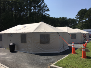
The Hampton Roads Incident Management Team (HRIMT) set up their tent city. We ran most of the exercise play from within the tents just like we would in a real response. Credit: Anne Condon, USFWS
During the drill, the agencies experienced a few hurdles. Internet communications were limited in the first few hours of the response, so units with paper copies of plans were more prepared and could respond faster than those who relied on internet communications alone. Hein noted that they felt “technologically frustrated,” but this complication highlighted an issue that they can learn from and improve upon before a real event.
The drill gave the team an opportunity to practice using the Eastern Shore Index to the Virginia Area Contingency Plan, a plan that helps prioritize the Eastern Shore’s resources for protection. It breaks up resources into groups A, B, and C, so that high priority areas are protected first either because they are ecologically sensitive, like shellfish beds or threatened and endangered bird nesting areas, or could protect additional resources, like primary inlets between barrier islands.
The agencies used this opportunity to practice identifying environmental priorities. Every spill presents unique challenges, including the time of year it occurs. For example, the mock spill was conducted in September, a time when whales wouldn’t be present yet and the nesting shore birds on the barrier islands had already migrated. While those species were excluded from this particular spill response, during a different time of year, those species would be a higher priority.
Hein noted that despite these practice measures, a spill of any kind would still be devastating. “Drills like this help us have the best response possible, but whenever there is a spill and we have to respond, it’s likely to be bad.” She added, “it’s not going to be the same pristine area it was before the spill as soon as a response is over. That’s physically impossible.”
The role of VIMS
Using scientific best practices in a spill response is crucial to protecting Eastern Shore habitat and mitigating the effects of a potential spill. The agencies rely heavily from scientific expertise at VIMS for making the best decisions possible.
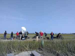
Personnel from Verizon and their equipment contractors test a variety of equipment on Parramore Island to facilitate communications between the field, staging areas in Wachapreague, and the Incident Command Post in Melfa. Credit: Sean Fate, VIMS ESL
The mission of VIMS is three-pronged: education, research, and also serve as an advisor to the Commonwealth. Researchers bring the latest marine science issues to the forefront and serve as a valuable resource in spill responses. Agencies are encouraged to contact the researchers with questions about fisheries, aquaculture, sensitive areas, shorelines, etc.
Data from VIMS is particularly useful because it provides a baseline for how the habitats looked before a spill. VIMS researchers also know the waterway channels. “Local knowledge is imperative to transit around the barrier islands,” explained Hein. “In addition to our scientific advisory role, we might be involved in telling responders how to get out there because we know these waters very well.”
Overall, these drills help agencies get on the same page and be as prepared as possible for devastating spills. Hein noted, “drills like this help responders have the best response possible during a spill and help the incident command make scientifically-supported decisions.”