
Aerial SAV Surveys Support Collaborative Science, Management, and Restoration
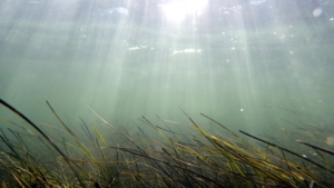
Submerged aquatic vegetation (SAV) is a vital component in the health of the Chesapeake Bay and worldwide coastal ecosystems. The SAV program, centered at the Virginia Institute of Marine Science (VIMS) is world-renowned for its monitoring and restoration projects. Robert “JJ” Orth, program director of the SAV monitoring and restoration program, started the program in 1978 which has made many important contributions in understanding the importance of SAV in the Chesapeake Bay for the last 40 years.
Collaboration is key
(Credit: Jonathan Lefcheck)
In 1984, resource managers began an annual Bay wide SAV monitoring survey using aerial photography to assess changes in SAV habitat. The most recent paper released about the aerial surveys of SAV highlighted the utility of the data in supporting a myriad of applications, from reductions in point source nutrient loadings to documenting commercial fishing impacts on SAV. Completing an annual Bay-wide monitoring survey is no small feat and collaboration among research institutions, state and local agencies, and individuals is key.
The aerial survey of SAV at VIMS is the only regular seagrass survey for a bay wide assessment of SAV, and because of that, the program’s data have been featured in several papers around the world. The seagrass survey was featured prominently in a paper published in 2009 on the accelerating loss of seagrasses across the globe.
“We’ve always been aware of the fun part of collaborating with people. You get a lot more from collaborating than anyone else. We try to embed people from different disciplines and different places to get different perspectives,” Orth said.
Orth highlighted the main reason their data has been so valuable is because it is publicly available. “We have made our data publicly available from day one and we’ve worked hard to make sure people have access to this data,” he emphasized. Ensuring public access to their SAV data allows others to examine their data and ask new questions, forming a foundation of collaboration.
The future of SAV monitoring
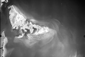
An example of the nature of aerial photographs collected each year during the VIMS bay grass monitoring program. This image, taken on June, 9, 2008, shows bay grass coverage in the vicinity of the Goodwin Islands near the mouth of the York River.
With climate change impacts, such as changing precipitation regimes, increasing in both frequency and intensity, the distribution and resiliency of SAV may change. Orth shared that repeated large-scale heat events that have changed the water temperature has pushed the overall distribution of eelgrass from deeper to more shallow waters. The issue, however, is that eelgrass is a true seagrass, meaning it cannot tolerate freshwater.
Orth shared that they intend to continue the annual survey and hope to look at emerging satellite technology as the next step. Satellite technology, however, does have its drawbacks, such as imagery not being publicly available. “Keeping up with technology has made it possible to save money and reach more people. We’ve gone from film photography in the early 80’s to digital cameras and now we can send pictures across the web.”
There is no doubt that the SAV monitoring program has been an unqualified success and plays a prominent role in tracking the effort to make the Bay cleaner and healthier for future generations.