
CRC’s Environmental Management Career Development Program works with the Chesapeake Bay Program partnership to offer three-year staff opportunities for science, management, and policy graduates as the partnership works to protect and restore the Chesapeake Bay. There are currently thirteen CRC Environmental Management Staffers supporting Chesapeake Bay Program initiatives for various lengths of time as each position follows its own timeline. The blended rotation of Staffers through the program affords new Staffers the opportunity to learn from the experiences of senior Staffers as they begin to navigate their way through the complexities of Chesapeake Bay restoration.
Lindsey Gordon is one of CRC’s senior Staffers in the career development program. For the past two years, she has been supporting the work of the Chesapeake Bay Program’s Water Quality Goal Implementation Team (WQGIT). Lindsey provides support to the WQGIT’s Land Use, Urban Stormwater, and Agriculture workgroups, along with their associated subgroups, where they have been working to meeting the goals and informational needs for the Phase 6 Bay Total Maximun Daily Load (TMDL) Mid-Point Assessment. In this capacity, Lindsey also provides analytical and technical support to the Land Use Workgroup, where she has developed and processed data to inform the Phase 6 Chesapeake Bay-wide land use/cover data, coordinated local government outreach efforts, and facilitated local engagement in the development of future land use forecasting scenarios. Let’s learn more about Lindsey and her experience thus far.
Lindsey Gordon is CRC’s Environmental Management Staffer working with the Chesapeake Bay Program’s Water Quality Goal Implementation Team.
CRC: Welcome, Lindsey! Thanks for chatting with us. You entered the Career Development Program and jumped right into working with the WQGIT during the ramp up for TMDLs Mid-Point Assessment, which is a critical moment for the Bay Program. What has been the most eye opening part of this experience for you?
Lindsey: I started my position with CRC right as the WQGIT began ramping up its workload to prepare for the Mid-Point Assessment. As a result, I’ve been involved in the process of using science to inform policy decision-making from start to finish. Some say this is like ‘seeing how the sausage gets made’, but it’s been a total learning experience for me, and I’ve really enjoyed it! I’ve truly learned the importance of communication, teamwork, coordination, and collaboration when it comes to using the Phase 6 Chesapeake Bay Model to help achieve our restoration and conservation goals under the TMDL. Overall, I think it’s been a pretty unique experience, and I’m fortunate I was able to participate in it.
CRC: You have a great technical background, particularly when it comes to data visualization and GIS. How have you been able to apply your skills to your work at the Bay Program?
Lindsey: From my first week in this position, I’ve been actively using my skills in GIS and spatial analysis to assist on-going work efforts at the Bay Program. I’m particularly involved in the work of the Land Use Workgroup, where I’ve helped translate and process local zoning data to develop the Phase 6 Chesapeake Bay-wide land use/cover data. Using this data, I also developed a watershed-wide spatial dataset of areas available for riparian forest buffers, which has been used by many partners to help guide targeted best management practice implementation. Recently, I’ve coded a script to generate a land cover time series annually from 1985-2014 using new USGS change detection data, and the new Phase 6 high-resolution land use data. Results allow me to track the rates of forest and impervious land cover change annually through time, and I plan to work with my coordinator to have them published. Up next, I’m working to spatially simulate storm surge inundation coupled with sea level rise projections in the Chesapeake Bay to help inform a set of land use forecasting scenarios being developed for the Mid-Point Assessment. In addition to these larger projects, I’m hoping to work with some colleagues to hold an informal mini-series to teach fellow staffers an Intro to GIS course – stay tuned!
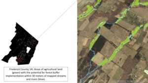
Lindsey’s map shows all agricultural areas (green) that are eligible for 30-m wide riparian forest buffer implementation. The data is part of a spatial inventory dataset of mapped land uses within a defined buffer width of all mapped rivers and streams in the Bay Watershed, and is helping guide implementation of riparian forest buffers and best management practices.
CRC: Sounds like you have had a busy two years digging into some really interesting work. Sign us up for your GIS class! At this point in the program, you are now considered one of our “senior Staffers.” What has been the most rewarding part of this experience for you thus far?
Lindsey: Without a doubt, some of the most rewarding aspects of this experience have been developing new connections in the scientific and policy community of the Chesapeake Bay Watershed, and working at the interchange of environmental science and policy. I started this position immediately after having finished my graduate program, with experience only in scientific research and academia, so one of the things that excited me most about getting to work at the Bay Program was the opportunity to engage in the broader process of utilizing science and data to inform on-the-ground policy implementation. Under the WQGIT, I’ve been able to work first-hand on research and analysis, and to then shepherd it through the Partnership structure and inform TMDL implementation and policy brought everything full circle for me. And of course, I would be remiss if I didn’t mention the incredible group of colleagues I’ve gotten to work with over these 2 years – it’s been an absolute privilege working with the fellow staffers and Bay Program staff.
CRC: As your time in the Career Development Program starts winding down, what do you hope to do next with all you’ve learned and accomplished at the Bay Program?
Lindsey: I’ve lived in the Chesapeake Bay Watershed for my entire life, and as much as I absolutely love it, once my time with the CRC ends I plan to move out to northern California in the Sierra Nevadas (note that coworkers will be strongly encouraged to come visit). With regard to career goals, I considered pursuing another graduate degree, but realized I’ve yet to fully recover from my first one. Instead, I find myself increasingly interested in land use, land management, and land conservation as they relate to watershed management, so I would love to find an opportunity with one of the many land trusts where I can continue utilizing my GIS skills to help guide conservation and restoration.
For additional information regarding CRC’s Environmental Management Career Development Program, please contact Melissa Fagan, Environmental Management Career Development Program Coordinator at faganm@chesapeake.org. Funding for CRC’s Environmental Management Career Development Program is provided through a cooperative agreement with the US EPA.