
Fighting Climate Change Starts Locally
From sea level rise to extreme weather events, the impacts of climate change are felt by all across the Chesapeake Bay watershed. Powerful storms and increased precipitation lead to nutrient pollution from runoff and stream erosion, higher temperatures can cause species to shift their habitat range and have human health impacts, and rising sea levels cause dangerous flooding and loss of property. These impacts of climate change threaten the recovery of the Chesapeake Bay, local economies, community health, and more.
Chesapeake Research Consortium (CRC) member institutions are deeply immersed in climate change research and actions across the region. Researchers at our member institutions are working with localities to develop tools and resources. These efforts range from studying sea level rise to visualizing climate change impacts on forests and in this edition of CRC Streamline, we’ll explore some of the actions being taken by these projects.
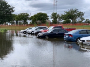
(Photo: Dave Mayfield, Norfolk)
The January and February CRC Roundtable webinars highlighted some regional research efforts in climate change and sea level rise. In January, two regional experts, Mark Bennett and Julie Reichert-Nguyen, discussed progress, challenges, and a way forward on delivering climate change information to local communities with the Chesapeake Bay Program’s Climate Resiliency Workgroup. February’s webinar built upon January’s climate resilience discussion to focus specifically about sea level rise. Ray Najjar of Penn State University and Wie Yusuf of Old Dominion University discussed the current and future impacts of sea level rise and how stakeholder engagement builds resiliency in communities. Recordings of the webinars can be found on the CRC Roundtable YouTube channel.
Rapidly Rising Seas
Flooding, storm surges, and other consequences of sea level rise are some of the most tangible symptoms of climate change and have had widespread effects on coastal communities across the world. The Virginia Institute of Marine Science (VIMS) issues annual sea level “report cards” that project sea level to the year 2050 based on an ongoing analysis of tide-gauge records for 32 localities along the U.S. coast from Maine to Alaska. The analysis includes over 50 years of water-level observations and the 2020 report cards show an accelerating rate of sea-level rise at 27 of the 32 monitored stations. The significant acceleration in rates of sea-level rise at these widely distributed localities hints at global drivers, with climate change the obvious suspect. Nowhere is this more apparent than along the coast of Virginia, where the sea level is rising more rapidly than the global average.
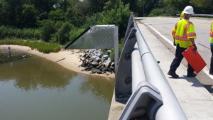
Sensor 2 located at 16th St. Bridge over Salters Creek
In Hampton Roads, flooding and sea level rise pose a problem to nearly every part of the city. The StormSense Project, led by Dr. Derek Loftis at VIMS, is an inundation forecasting research initiative meant to provide the public with more information faster. The project has over 40 water level sensors installed through cooperative agreements with municipal governments throughout Hampton Roads, Virginia. Dr. Loftis said the sensors can provide forecast guidance up to 36 hours in advance telling people what places are likely to be flooded and allowing them to plan their day around the projected areas that will flood. Eventually, the information could even be used in driving apps to direct traffic around flood areas.
The purpose of the project is to “enhance the capability of communities to prepare and respond to the disastrous impacts of sea level rise and coastal flooding in ways that are replicable, scalable, measurable, and can make a comparable difference worldwide.” The project hopes to enhance the field of emergency preparedness by advancing research to help predict flooding resulting from storm surge, rain, and tides. “They are used short term from an emergency management perspective,” said Dr. Loftis, “but also long term; they allow us to better understand sea level rise.” While storm sensors have been used for years, Dr. Loftis says recently they’ve added a lot more at a lower cost in hopes of providing more information – and faster – to the public. “Our goal is really to become more resilient to those types of events in the future and flood preparation is the first key,” said Dr. Loftis.
Building Resilience
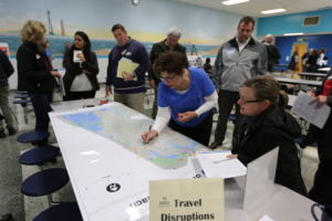 A research team from Old Dominion University (ODU) Institute for Coastal Adaptation and Resilience designed the Action-Oriented Stakeholder Engagement for a Resilient Tomorrow (ASERT) framework to engage stakeholders in adaptation actions in response to flooding and sea level rise. ASERT was designed to facilitate building community resilience by promoting collaboration and effective communication. Wie Yusuf, the head of the program and professor in the School of Public Service at ODU, explained that many Hampton Roads residents want to be part of the decision-making, but don’t know how to get involved. In the demonstration pilot project, residents engaged in participatory mapping on the weTable where they could visualize and identify community assets threatened by SLR, allowing for the team to capture priorities for residents. Yusuf highlighted that this concept allowed participants to add a narrative to the map they were drawing. She shared that as more stakeholders participated in the demonstration, they realized they could make a difference and were able to speak in a more constructive way.
The ASERT framework has been applied to other contexts, such as the City of Virginia Beach Comprehensive Sea Level Rise Planning Process. Virginia Beach was considering six different massive infrastructure projects and wanted input on how residents perceived and prioritized the different projects. Yusuf shared that using ASERT, her team was able to collect data that provided the city with some preliminary insight into how this information would be received. They incorporated these insights early into the planning process and were able to provide solutions when it came time for public feedback.
Beyond the Coastline
Impacts of climate change extend beyond the Chesapeake Bay and the coastline. Visualizing Forest Futures (VIFF) is a National Science Foundation (NSF) funded project at Penn State University (PSU) centered around the Menominee Nation, an indigenous people in the Great Lakes region, facing cultural and economic challenges as climate change impacts their forest home.
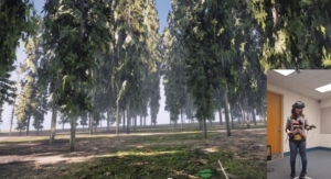
A user exploring how specific species (such as red pine) responds to climate change. (Photo: Jiawei Huang)
Erica Smithwick, associate director of the Institutes of Energy and the Environment (IEE) at PSU, is the principal investigator of the project and works in collaboration with an interdisciplinary team and in partnership with the Menominee to better understand how tribal values and customs inform the types of decisions the nation will face due to a changing climate. “The Menominee are increasingly noticing that there are threats to their forest sustainability practices,” said Smithwick. “They are noticing maybe some species aren’t doing as well, and some trees are suffering from pests or pathogens. They are wondering how their ability to manage the forest will be impacted if those disturbances become more severe.”
The project includes a virtual reality (VR) component that will allow stakeholders to visualize forests as they are today and in the future. The VR experience takes into account forest management practices of the Menominee Nation and the National Forest Service and several models, including climate change models, vegetation, and ecological models, to simulate the forest in 2050 to see how biodiversity and economic factors will be impacted. “Maybe the forest looks similar, except the species are different,” Smithwick said. “Now imagine that perhaps that missing species was one from which you used to harvest berries when you were growing up. For you, that would be a big loss. We are hoping that being in the virtual environment helps people perceive the loss in a different, more visceral way.
Tackling the issue of climate change must involve breaking out of the traditional silos of research and be a multi-faceted effort. This article highlights just some of the many climate change research projects and actions that CRC’s member institutions lead across the Chesapeake Bay and beyond. Research that includes actions at a local level are especially important as communities wrestle to understand the range of projected impacts and how to effectively plan for and respond to climate change impacts.