
Researchers from Old Dominion University (ODU), Virginia Tech (VT), and the University of Kentucky have created a software program that can help determine the best places and designs to create freshwater wetlands. The tool, called Wetbud, is free and easy to use for anyone, particularly engineers, scientists and regulators. It works by pooling data on water flows, slopes, evaporation, weather, soil, and topography to calculate the water inputs and outputs from a particular site and predict how an area will behave under normal, wet, and dry year conditions.
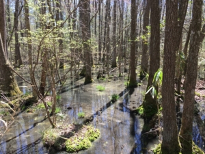
Wetbud was used to help analyze this site at ODU’s Blackwater Ecological Preserve near Zuni.
Wetlands have been protected under the Clean Water Act since 1977, but they can still be legally destroyed by groups that have special permits. These permits require wetlands to be built nearby, often at a rate of two acres created to every one acre destroyed. Before Wetbud, engineers and scientists could spend months compiling data for a particular site to figure out if it would retain enough water to support wetland vegetation throughout the year. Now, Wetbud can compile that information in seconds.
The software is so good at helping choose and design wetland mitigation sites that the Army Corps of Engineers has approved their staff to use it. In order to choose a site, the Army Corps require permit applicants to prepare a water budget for the site in wet, dry, and normal years. Wetbud calculates the water budget at the site and produces hydrographs under those three scenarios, and applicants and regulators can compare these results to Army Corps standards and pick the site design that will mostly likely result in the most successful wetland possible.
“You want to do it right the first time,” explained Rich Whittecar, an ODU scientist on the team who created the software. “You need the right water levels for wetland plants to survive to replace the ones you’ve destroyed.”
Whittecar has studied hydrogeology and wetlands for years, and his previous work with Lee Daniels, a soil scientist at Virginia Tech, got him involved with Wetbud. Daniels and Whittecar had known each other for decades, so when Daniels saw an RFP from the nonprofit The Resource Protection Group, Inc., which was formed by Michael Rolband of Wetland Studies and Solutions, Inc., on water budget modeling, he recruited a wetland dream team “to really go after this,” explained Daniels. He also brought on Tess Thompson, a VT Biological Systems Engineering Department professor, and Zach Agioutantis, a former VT Mining Engineering PhD student and post doc who is now at University of Kentucky and led the software’s programming. When asked about the collaborative nature of this unique team, Daniels added, “I’ve learned a lot from this project…It’s been a pretty remarkable project that we’ve involved all these disciplines.”
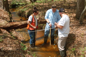
ODU graduate students using Wetbud in the field.
The team has been working on Wetbud for 8 years thanks to a generous grant of $1.6 million from Mike Rolband of Wetland Studies and Solutions, Inc. via The Resource Protection Group, Inc. In the 90’s, Rolband negotiated a deal with state agencies in which if he successfully met a set of goals related to designing wetlands, he would be granted additional wetland credits. This goal was first achieved in the mid 2000’s and he agreed to use the money from these additional credits to fund wetland research and monitoring. He used the sale of his credits to start a nonprofit that would eventually fund Wetbud, which is one of three primary wetlands research efforts being funded by his non-profit. “We want to make it easier for designers to try different scenarios and for regulators to check these designs more easily,” explained Rolband.
Right now, a basic version of Wetbud is available online and is already being used on wetlands ranging from a few tenths of an acre to dozens of acres. It models the different flows of water moving in and out of a potential new wetland site with a simple two-dimensional modeling approach. It has been tested at multiple sites and has proven useful to engineers and other researchers. An advanced version of the model is still being tested, and the team hopes to have it debut in the fall. That version will offer a three-dimensional look at differences in topography and can take into account vegetative resistance to water flow. While Wetbud can be used for modeling, “the intent of the model is to help design wetlands, not model what natural wetlands do,” explained Daniels.
Although engineers certainly use and benefit from Wetbud, they are not the only ones who can use the software to their advantage. “One of our goals was to make [the software] so simple that folks who weren’t engineers who work at the state agencies to feel comfortable using the program,” explained Whittecar. They want to attract regulators to use the software to better understand and protect wetlands. In addition, researchers are already using the tools in Wetbud, to collect weather data in order to reconstruct groundwater levels that go back as far as the 1890’s for conservation projects and wetland research.
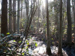
Wetbud was also used to analyze the water budget at First Landing State Park.
The team is eager to expand Wetbud, including on the entire east coast. “We would like to be able to develop the easy-to-use data sets for other places,” said Whittecar. “We’ve done it for Virginia and some of Maryland, but we need funding to fill in the gaps in data in other places.” Rolband is also preparing a similar research initiative dedicated to improving urban stream restoration. This summer, he’ll be brainstorming with researchers and regulators on the potential introduction of freshwater mussels, among other methods, as a potential restoration mechanism.
Wetbud will help engineers and scientists in Virginia design better wetlands, and that has huge implications for the Chesapeake Bay. “Wetlands provide essential ecosystem services including filtering nutrients and sediments and buffering against storms. Anytime you can increase the functions of wetlands and make them more efficient, that improves the water quality and provides new habitat,” explained Whittecar. “[Wetbud] makes it easier to build more successful wetlands with greater confidence.” Daniels added, “Anything we can to do improve wetland creation success means we’re going to do a better job replacing the functions that these sites are designed to replace.”